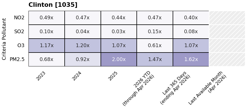
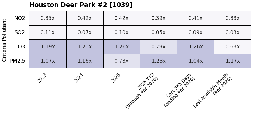
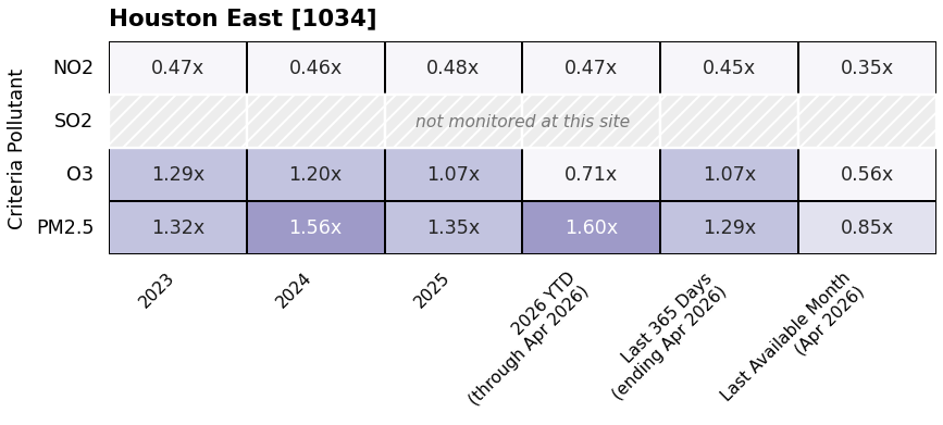
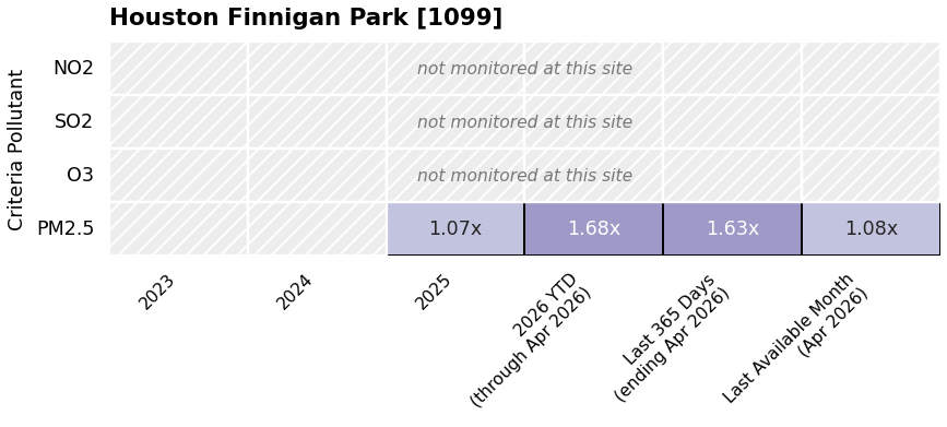
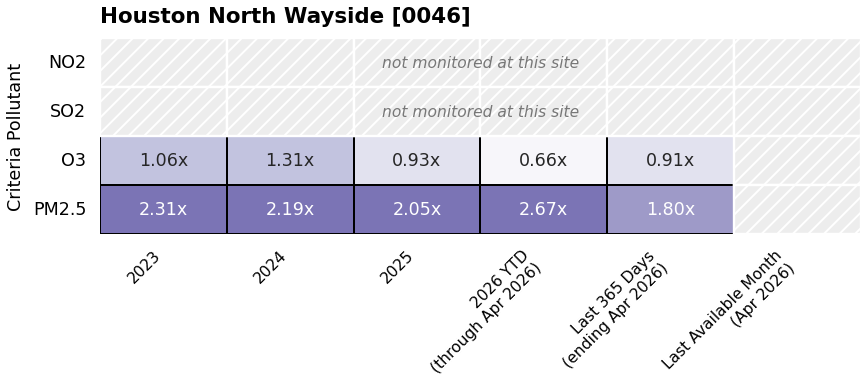
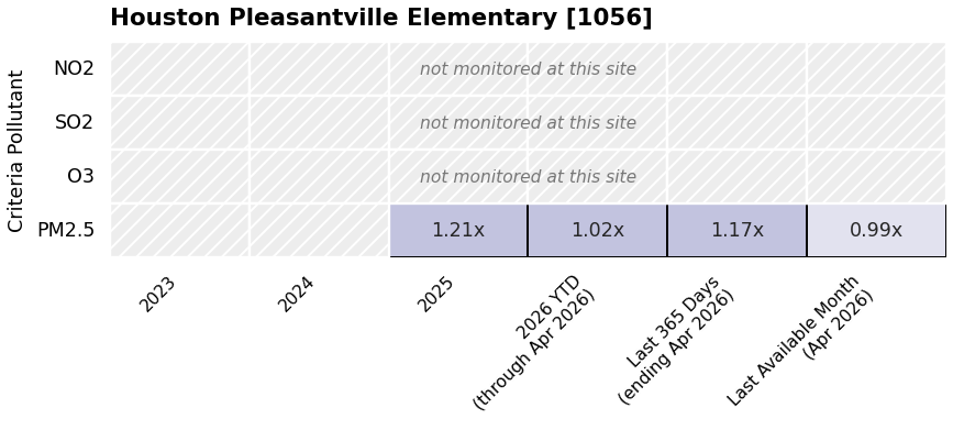
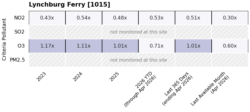
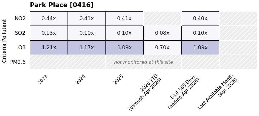
The Clean Air Act identifies 6 air pollutants that pose the greatest health risks. They are known as criteria pollutants. This section tracks four EPA criteria pollutants, sulfur dioxide (SO₂), nitrogen dioxide (NO₂), ozone (O₃), and fine particle pollution (PM₂.₅), measured at state-run (TCEQ) regulatory monitors in the same part of Harris County as the AutoGC sites — the eleven EPA-registered monitoring sites that lie within the area of the monitor map, from Clinton Drive to Baytown. Four of them (Clinton, Channelview, Lynchburg Ferry and Houston Deer Park #2) are also AutoGC monitors. Each location card below shows all four EPA criteria pollutants tracked, so every site can be read as a complete picture of its criteria-pollutant concerns.
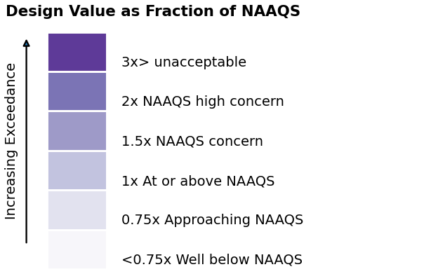
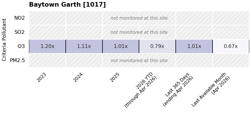
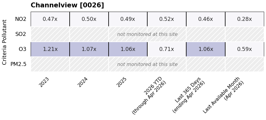
The EPA uses air monitoring data to determine if pollution levels meet the Clean Air Act requirements. They make these decisions based on a number representing all the measurements over a year taken at an air monitor. It is called a Design Value. It represents the highest pollution levels in that area. In the figure, each cell shows the EPA Design Value for that pollutant divided by the corresponding National Ambient Air Quality Standard (NAAQS). A value below 1.00 means the design value is within the standard; values above 1.00 indicate the yearly average is greater than the Clean Air Act (NAAQS) standard and poses an increased health risk. Design values are computed using the same statistics EPA uses to determine if air pollution levels in the region are meeting the criteria set by the Clean Air Act. Columns cover single-year design values plus a year-to-date column, a rolling Last 365 Days window and the Last Available Month. EPA AQS releases data on a delay of weeks to months, so each of those three headings names, on its second line, the month the criteria data actually ends in. The color scale is shared across all locations, so cards can be compared directly.
Not every monitor measures every pollutant. Hatched gray cells mean no measurement exists — a pollutant that is not monitored at this site is shown as an empty hatched row rather than being hidden, so a gap in coverage is never mistaken for a clean reading.
How to read this plot (click to expand)
Each row is one of the six EPA criteria pollutants. Only four EPA criteria pollutants are measured. Each column is a period of time. Unlike the other tabs, the number here is not compared to a screening level — it is the EPA design value divided by the National Ambient Air Quality Standard (NAAQS), written as a multiple with an “x.”
A design value is the particular statistic EPA uses for each pollutant when comparing a monitor against its standard, rather than a simple average. (The FAQ explains which statistic is used for each pollutant.) Below 1.00x means the pollutant is within the standard; above 1.00x means it is above the standard.
A clarifying example.On the Houston East card, find the row for O3 (ozone) and the column for 2023. The square reads 1.29x. That means ozone’s design value for 2023 was 29% above the national standard. In the same column, NO2 reads 0.47x, comfortably under. Ozone is above the standard at every Houston criteria site that measures it in 2023, 2024 and 2025.
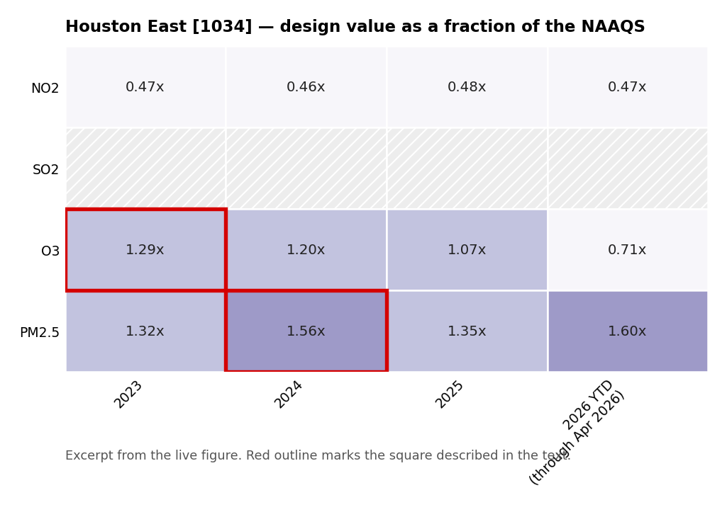
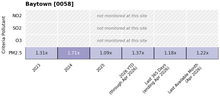
Fine particles also exceed the standard. On the same Houston East card, PM₂.₅ reads 1.56x in 2024 and is above 1.00x in every period shown. Baytown reaches 1.71x in 2024 and Clinton 2.00x in 2025. Seven of the eleven sites measure PM₂.₅, and all of them are above the standard in most periods. (The comparison here is against the 24-hour PM₂.₅ standard.)
The last three columns name their ending month. The other tabs run to the most recent TCEQ data. EPA AQS, the source for this tab, releases data weeks to months after the fact, so the year-to-date, Last 365 Days and monthly columns here each carry, on a second line, the month the criteria data actually ends in — for example “Last 365 Days (ending Apr 2026)” is the 365 days up to the end of April. A site whose own data ends earlier than that month shows a blank cell rather than older data.
Hatched gray rows labeled “not monitored at this site” mean that monitor does not measure that pollutant at all. Coverage is uneven: sulfur dioxide, for instance, is measured at only three of the eleven sites (Clinton, Park Place and Houston Deer Park #2), Baytown Garth measures ozone only, and Baytown, Finnigan Park and Pleasantville Elementary measure PM₂.₅ only.
One caution. These are single-year values. EPA’s official design values, the ones used to decide whether an area meets the Clean Air Act standard, averages three consecutive years to make a decision, ensuring that a single stand out year does not unduly influence compliance determinations. So a value above 1.00x here is a signal worth a closer look, not an official finding that the area violated the standard.